|
THE GIANT'S CAUSEWAY
Around 40,000 interlocking hexagonal basalt columns, said to have been made into a causeway by the Irish giant Finn MacCool so that he could fight the Scottish giant Benandonner. The other end of the causeway is located on the Scottish Isle of Staffa, at Fingal's Cave, with its identical basalt columns. See on the Map-olah Map:
0 Comments
The lost lands of Welsh King, Gwyddno Garanhir, lay submerged beneath the waves.
The town of Cantrer Gwaelod had stood below sea level protected by sea walls but a drunken Seithennyn forgot to close them one night and a storm submerged the town as its people fled. See the petrified forest at Ynyslas, as you listen out for the ring of the bells sounding from the lost church. See on the Map-olah map: https://www.zeemaps.com/view?group=2653234&item=The_Welsh_Atlantis_-_Cantre'r_Gwaelod THE OLDEST POST OFFICE IN THE WORLD, SANQUHAR
Sanquhar has the oldest working Post Office in the world, at over 300 years old! It dates back to 1712, having originally been a staging post for mail carriages and has stables behind to rest the horses. So that's over 300 years of continuous service. 1712, that's the year the Duke of Montrose issued an arrest warrant for the arrest of legendary Scottish outlaw Rob Roy McGregor - was it posted?! Whilst Peter the Great of Russia moved the Russian capital from Moscow to St. Petersburg that year, and political philosopher . Jean-Jacques Rousseau was born. See on the Map-olah Map: https://www.zeemaps.com/view?group=2653234&item=Sanquhar_-_The_Oldest_Post_Office_in_the_World! MANORBIER CASTLE Fantastic Norman Castle dating back to the end of the 11th Century overlooking Manorbier beach. Birthplace of historic scholar Gerald of Wales 1146 -1223, who said of Manorbier - 'In all the broad lands of Wales,Manorbier is the most pleasant place by far', he may have been biased but it is difficult to disagree, it is certainly a jewel in Wales' crown. See on the Map-olah Map: https://www.zeemaps.com/view?group=2653234&item=Manorbier_Castle 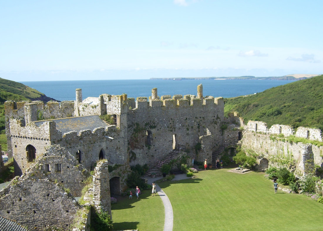 Sweetheart Abbey, the Abbey with the romantic name, that commemorates the romance that led to its founding.
When Lady Dervorgilla's husband, Lord John Baliol died in 1268, she had his heart embalmed and placed in an ivory casket that she kept with her. In memory of her husband Lady Dervorgilla made numerous acts of charity, one was the founding of Dulce Cor Abbey - Sweet Heart - Abbey in Latin. When Lady Dervorgilla died, she was buried below the high altar with her husband's heart. See on the Map-olah map: https://www.zeemaps.com/view?group=2653234&item=Sweetheart_Abbey Robin Hood's Stone, in Allerton, Liverpool is a single standing stone, that once stood in a nearby field where Tudor Liverpudlians practised their archery.
Henry VIII had made it law that all men under sixty practise archery, and so fields were set aside with mounds to support targets, and where the archers stood to fire their arrows would also be placed a stone to allow the sharpening of arrows. The Robin Hood Stone is one of these stones, which has deep groves cut into its surface where the arrows were sharpened, though these may have begun with natural abrasions to the stone. It is likely that the stone had had an earlier human use, possibly as part of tumulus burial chamber, and has been moved from the location of the Calder Stones several times. The grooves on the stone do not go below the surface, where hollow cup marks were found on the stone. The Robin Hood link is uncertain, other than the link with archery. This is the Archers' stone of Archerfield Road. See on the Map-olah map: https://www.zeemaps.com/view?group=2653234&item=Robin-Hood's_Stone_-_Liverpool Lyme Regis is famous for its Fossils, and Mary Anning was the pioneering female fossil hunter - the 'Princess of Paleontology', 1799 - 1847.
She discovered the first ichthyosaur (aged 12), first plesiosaur and first British pterosaur. Her range of scientific discoveries did not gain her the credit they deserved, in the male dominated scientific community at the time. She took on the family fossil business, selling samples to the King of Saxony, and for display at the forerunner to the New York Academy of Sciences, the Lyceum of Natural History. She is buried in St. Michael's church, where there is a window dedicated to her. In 2010 the Royal Society placed her in a list of the ten British women who had most influenced science. See on the Map-olah map: https://www.zeemaps.com/view?group=2653234&item=Mary_Anning,_Fossil_Hunter Pevensey Bay, Site of the landing of William Duke of Normandy's fleet of Norman forces prior to the Battle of Hastings, where the Anglo- Saxon Harold II was defeated and William became William I of England and thus William the Conqueror.
The events are shown in the Bayeux Tapestry. See on the Map-olah Map: https://www.zeemaps.com/view?group=2653234&item=1066_-_Pevensey_Bay_-_Norman_Invasion Map-olah's pages are now adorned with our new logo.
The logo is hopefully a bright and positive addition for the New Year, with refinements to be added as we go on. Sightings of a dragon at Henham-on-the-Mount were reported in a pamphlet of 1669 - "The Flying Serpent or Strange news out of Essex".
Numerous locals were said to have attested to the sighting and further sightings continued after the pamphlet. Find Henham home of the 'Essex Serpent' on the Map-Olah map: https://www.zeemaps.com/view?group=2653234&item=Dragon_of_Henham |
AuthorWrite something about yourself. No need to be fancy, just an overview. Archives
March 2018
Categories
All
|
 RSS Feed
